This tool will calculate the the Start and End coordinates for a Drainage Link (Segment), and store the values as attributes on the Link.
NOTE:
Only applies to Drainage Strings. All other strings are ignored.
The position of coordinates are calculate where the drainage pipe intersects the inside wall of the pit.
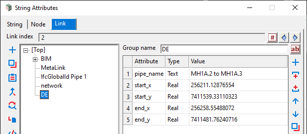
An attribute group, DE, will be created on each Link, and contain the following;
- pipe_name
- start_x
- start_y
- end_x
- end_y
The Start/End position are based on the pipe Flow Direction. So if the pipe flows downhill, then Start will be the Upstream end.

- Model for network – Select model containing drainage network.
- Include Longitude/Latitude (Optional) – Provide extra attributes for Lat/Lon*.
- Clear Output Window (optional) – If ticked, clears the Output Window of all previous messages.
* When including Lat/Lon, the Projection must be set first;
More info – transport.12dwiki.com.au/set-projection/
Current Limitations
1. When using the Node>Connect Mode: Unrestricted, and the pipe stops-short of a pit (such as with an orifice plate), coordinates calculated at the END of the pipe, NOT at the pit.

2. For multi-barrel pipes, coordinates are calculated at the assumed center for a single barrel. Therefor, only a single set of attributes are provided.
3. When using Node Connection Points
Global>Use Node Connection Points: On
Coordinates are calculated at the pipe connection point.

Global>Use Node Connection Points: Off
Coordinates are calculated where the center of the pipe intersects the inside wall of the pit.
